Glacier National Park--Logan Pass

15 June, 2013


Heavy Runner Mountain.


You'll notice that this page is called "Logan Pass." We weren't supposed to be able to go to the Logan Pass, were we? It was supposed to be closed for another week. We were supposed to spend Saturday driving the west side of the Going-to-the-Sun Road up to Avalanche Creek. My friend Joe the photographer had recommended a 7-km hike to Avalanche Lake that we were trying to fit in. Logan Pass?

As we were leaving the lodge, after a good night's sleep at last, we saw a man standing facing the flag loudly singing "The Star Spangled Banner." A man in uniform was sitting in a rocking chair on the porch, and told us that that guy stood there and sang to the flag every day. The uniformed many seemed to think it was kind of crazy, but the guy was a reasonably good singer, so it didn't seem like a terrible thing to us. It turned out that the uniformed man was the driver of one of the 1930's red buses. He told us his 9:00 trip was going to be the first to the Logan Pass this year, because the road to the Logan Pass had just opened up that morning.

Oh, my. What should we do? Going to the Logan Pass would probably mean missing the whole west side of the park altogether. We asked the man, and he said that, while both were nice, if we wanted to do photography, we should go to the Loan Pass. "Let's go, honey!" I said.

We went back to Luna's and had another great breakfast, but the wi-fi was down. That was disappointing.

Two of the red buses together.


The red bus climbing up to the pass.


The Going-to-the-Sun Road at Piegan Point Trailhead.


Deep snow still beside the road as we approached the pass.


Eric at the sign for the Logan Pass. Not as high as the Continental Divide crossings in Yellowstone, but somehow more beautiful.


When we saw that the driver had opened the hood of the red bus, we ran over to check it out.


The red buses have been retrofitted with propane engines to preserve the air in the parks. Looks quite different from a gasoline engine, huh?


Passengers sticking their heads out of the top of the bus. Photo by Eric.


Eric took a pretty picture of a mountain with snow on it.


Someone pointed out mountain goats up on the mountain. Unfortunately, one of them had his butt turned to us.


Mountains near the pass.


Eric demonstrating the height of the snow on the way up to the bathrooms.


Eric took a picture of the pretty local rocks the Park Service had used for the sides of the bathroom building. The red rocks are mudstones.


Eric posing with the scenery.


He took a picture of snow on a mountain. There is a small waterfall near the bottom of the picture.


While the road wasn't open to cars yet, it was open to cyclists. Part of me wished we had bikes with us; another part noted that I was cold even wearing a wool sweater, wool hat and winter coat, and would probably have lost a couple of toes to frostbite on the way down. The temperature varied between 4 and 7 degrees, depending on whom you asked.


Lots of cyclists from northwestern Montana had come to ride the Logan Pass on the last weekend before it opened to car traffic. I could entirely see the appeal. Photo by Eric.


Eric figured out that, if the road west of the pass was open to cyclists, it must also be open to pedestrians. He also figured out that there was a cache nearby that promised a waterfall.

"We can't go a day without a waterfall hike, can we?" I asked.

"You're going to have a hard time come Tuesday," he replied.

We headed out on foot. Photo by Eric.


Tremendous views just west of the Logan Pass.


Occasionally, this odd mountain feature would poke its way out of the clouds. It looks like a volcanic spine, but given where we were, I'm assuming it's actually caused by weather erosion.


Eric took a picture of the park's heavy-duty snow removal equipment, which he called, "Mama Bear, Papa Bear, and Baby Bear."


We came to the waterfall, which wasn't exceptionally impressive.


On the way back up, Eric took a picture of some blue snow.


A small waterfall was peeking out of the snow.


A tree also peeking out of the snow, parallel to the earth.


Back on the road, we stopped at some overlooks we'd skipped on the way up to make sure we had enough time to make it to the pass. How many waterfalls can you see in this picture?


There are three major ones, plus some smaller ones.


Eric got a good picture of the third one.


Heavy Runner Mountain.


Eric took a picture of an unidentified but beautiful mountain near Heavy Runner.


The road had a tunnel.


The Jaguar on the road.


Back in the St. Mary area, Eric took a picture of Jackson Glacier.


Now, we had to drive back outside of the park, and down around on the other road to the west side. The ranger, trying to reassure me when she told me we wouldn't be able to go all the way over the Going-to-the-Sun Road, had told me we'd get to see a goat lick.

We saw the goat lick, but we didn't see any goats. At least we got to see them in the Logan Pass. There was a cool railroad trellis, anyway.


We decided to drive a little ways into the park on the west side of the Going-to-the-Sun Road, just far enough to get a good view of Lake McDonald. This part of the park is much lower in elevation than the other side. Photo by Eric.


Lake McDonald. Photo by Eric.


We hurried back to get on the way to Missoula without going to see McDonald Falls, because Lulu was telling us we were not going to get to Missoula until almost 21:00. Although I expected the University of Montana town to have more restaurants open late, I didn't really want to take chances, and wanted to pad our time a little bit. After we got out of the park, though, Lulu changed her mind and told us we had another hour. We felt cheated.

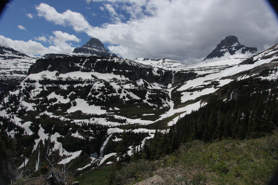
I wish we had gone all the distance we could have on the west side of the road, but at least we got to see the Logan Pass!

Distance hiked: about 2 km (on a paved road)?

On to Craters of the Moon National Monument and Preserve.


Last updated: 15/06/2013 by Eric and Beth Zuckerman