South Forks Lakes
Sunday 30 July, 2023
Lower South Forks Lakes.
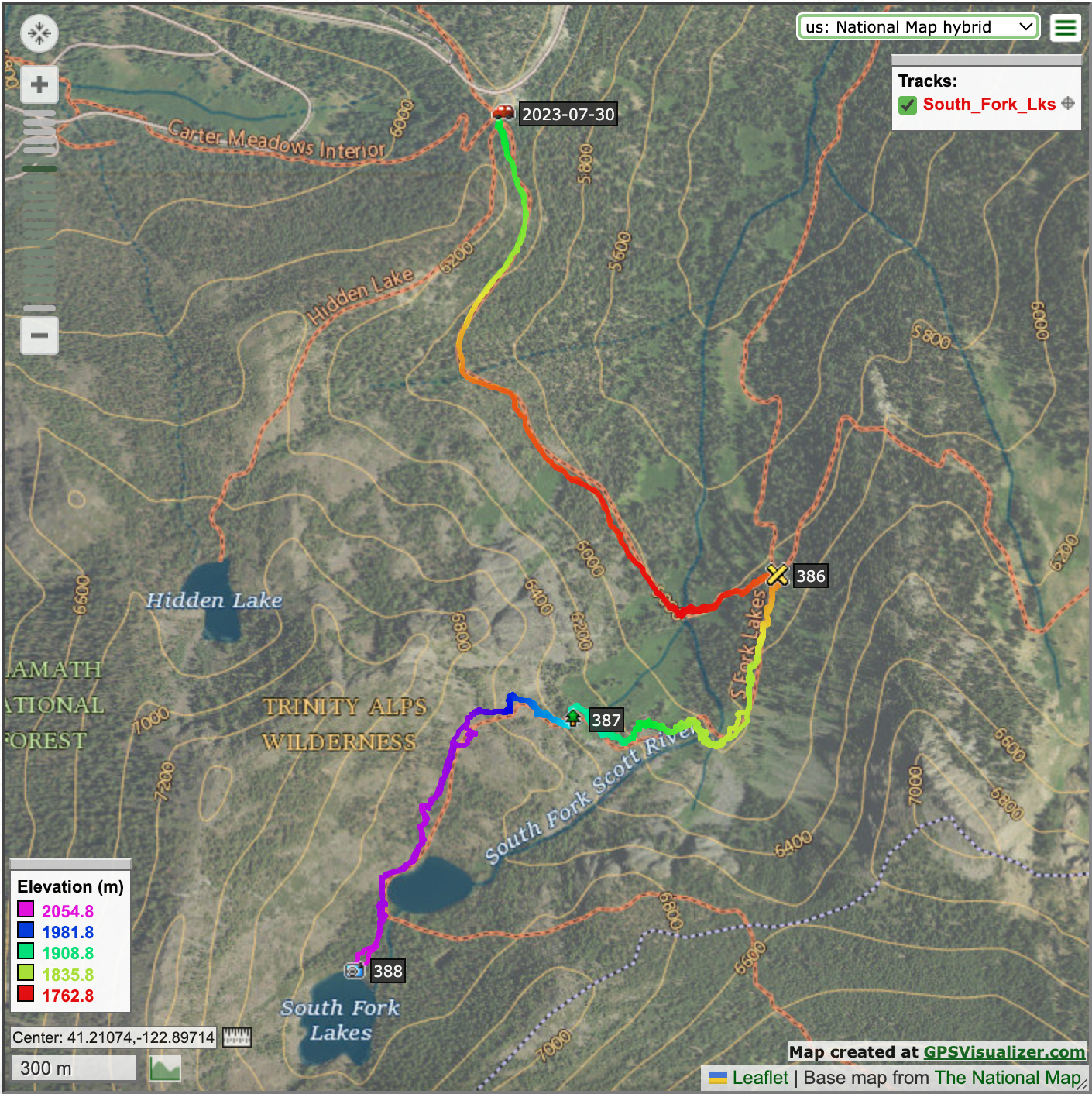
After an early night the night before, we rose early and made a breakfast of eggs and vegetables in the cabin kitchen before setting out on the marquee hike of the trip, South Forks Lakes. We discovered belatedly that our location just south of Trinity Center was much further from the trailhead than expected. The previous year we had stayed further north, deeper into the Trinity Alps region. The trailhead was more than an hour's drive from the cabin. We had considered taking a longer hike, but had to abandon that plan.
Our route started out on the famed Pacific Crest Trail. Eric took my picture at the sign.
Immediately upon leaving the small parking area, we entered the wilderness. I took Eric's picture at the sign.
The trail set out through an area that unfortunately burned a few years prior.
Eric found a butterfly along the trail.
Wildflowers bloomed in the midst of the burned area.
We went through an unburned area and walked through a meadow. Photo by Eric.
We met three other hikers while on the PCT. All were through-hikers, going from the Mexican border to the Canadian border. The first was a solo hiker, a real ragamuffin. He was incredibly dirty, but seemed very happy. The other two were hiking together, and told us that a third companion was convalescing from an injury.
We saw this beautiful Western Tanager.
I found a fascinating shelf fungus.
We turned off of the PCT and headed uphill toward our lake destination.
The trail had a 320-m/1,050-ft elevation gain, so we climbed and climbed.
We climbed higher and higher, closing in on this glacier-carved cliff.
At last, we reached Lower South Forks Lake. Photo by Eric.
Lower South Forks Lake was beautiful, but the book promised that Upper South Forks Lake was prettier.
The hike to Upper South Forks Lake was not much further.
Upper South Forks Lake.
Eric found a salamander in Upper South Forks Lake.
I look a picture looking up through the trees.
I was able to swim in Upper South Forks Lake, but only a little bit. The water was warmer than it had been at Clear Creek, but up there at 2,057 m/6,750 ft, the water was still quite cold.
We saw woodpeckers.
I found this unique marbled rock.
We spent about an hour relaxing and snacking beside Upper South Forks Lake before beginning the steep descent.
The view from the top of the ridge just beyond the lakes.
The trail down was steep with switchbacks, and covered with loose scree, making the footing difficult.
I looked down at a large talus pile below us.
The hills rose above us.
The trail turned, revealing this beautiful view of the forest below and the hills in the distance.
I was fascinated by bits of whitened dead wood along the rocks on the trail.
As we crossed the stream at the low point on the trail, Eric photographed a small waterfall.
As we made the final ascent back to the parking lot, the sun lit up these wildflowers.
We completed the hike in about 7.5 hours, with 2 hours of daylight to spare. We had planned to do another hike from the same trailhead the next day, but came to the conclusion that this trailhead was just too much of a long drive in the opposite direction from home, and that we should find a different hike along the way for our return on Monday. Eric made us a great dinner back at the cabin, of pesto pasta with chicken meatballs for dinner.
Map of hike to South Fork Lakes
On to Iron Canyon.